Additional Volcano Information
Keep track of the lava’s progress, if any, down the pali (‘pah-lee’ “hill”) through the links below. There are two eruptive vents: 1. Pu‘u ‘Ō‘ō, in Kīlauea’s East Rift Zone (ERZ), which started on January 3, 1983 and is still erupting, and 2. an eruption in Kīlauea’s summit, below the floor of Halema‘uma‘u pit crater, which began in March of 2008. You can call the County government’s recorded-information number at 1-808-961-8093 and/or the HVNP recorded-information number at 1-808-967-8862, for daily updates. Conditions change frequently, so do refer to the links provided, for more updated information about the Park and the eruptive vents.
In early March of 2011, fissures temporarily cut off the supply of magma to the ERZ vent, which immediately stopped the flow of lava down the pali, but which created quite a show, visible from helicopter and, now, videos on Web sites. The fissures were open for less than a week, then the magma resumed flowing, through underground conduits, into Pu‘u ‘Ō‘ō; it built up a perched lava lake inside that cinder cone, clear up to the top of its walls. Then, on August 3rd, like someone who’d eaten too much and whose clothes become too tight and rip at the seam, Pu‘u ‘Ō‘ō split open and a huge volume of lava gushed out in just hours, in an isolated event. The Park has videos on its Web site of that, and other, events.
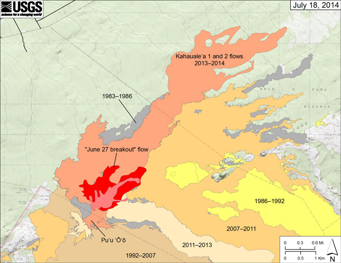
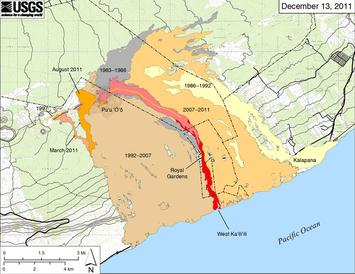
Then, beginning in September, 2011, surface lava flowed southeast of Pu‘u ‘Ō‘ō and down the pali, through what’s left of Royal Gardens Subdivision, reaching the ocean again in December, inside the Park boundary for the first time since 2007, while the perched lava lake refilled Pu‘u ‘Ō‘ō, in the ERZ (East Rift Zone). Some of the lava went underground through pyroducts (lava tubes). After a fairly brief period, the lava again backed up the pali, and there were no visible surface flows, through January and most of February, 2012. Toward the end of February, surface flows headed back down the pali, eventually reaching the ocean again by Summer, 2012. The hike to the flows from the viewing area at the end of Hwy. 130 has been taking about ninety minutes in each direction. The second-to-the-last house in Royal Gardens (“Jack’s house”) was burned and buried, on March 2nd. The only remaining house was abandoned fifteen years ago. The surface flows moved further away from the County government’s viewing area, a short walk from their parking area, such that the hike out to the surface flows was taking two hours, each way, in July and August, this year. After over a year of entering the ocean, from Summer of 2012 to September of 2013, the ERZ surface flows backed up the pali, again. Be sure to check the HVO Web site for updates, before making plans.
As noted above, the summit eruption, at HVNP, has been sending up an effervescent plume and producing a glow that’s visible after dark, from Jaggar Museum, up at Kīlauea’s summit. The Hawaiian Volcanoes Observatory (HVO) Web cams help you see the lava pond at Kīlauea’s summit; the surface flows, east of Pu‘u ‘Ō‘ō, and the perched lava lake, inside it, are sometimes visible through the Web cams. Two roving Web cams are set up wherever they’re needed, depending on where the lava is flowing.
Sometimes, the best way to view the lava is not from the ground, but from the air, as the heli tours can offer views of the volcanic activity during daylight hours. There are a number of heli-tour companies offering flights out of Hilo airport, as well as Kona and Waikoloa airports. Unless the lava is entering the ocean (check the NPS and HVO Web site sites for updates), the lava boat tours wouldn’t be helpful in viewing lava; a concern about the boat tours is that the boats sometimes motor through the toxic plume emitted by the lava when it enters the ocean; the plume is comprised, in part, of hydrochloric acid and tiny particles of volcanic glass.
HVNP reopened the trail to Nāpau, beginning 8/13/11. The map below shows re-opened trails and the viewing areas, along the trails and roads in the Park.
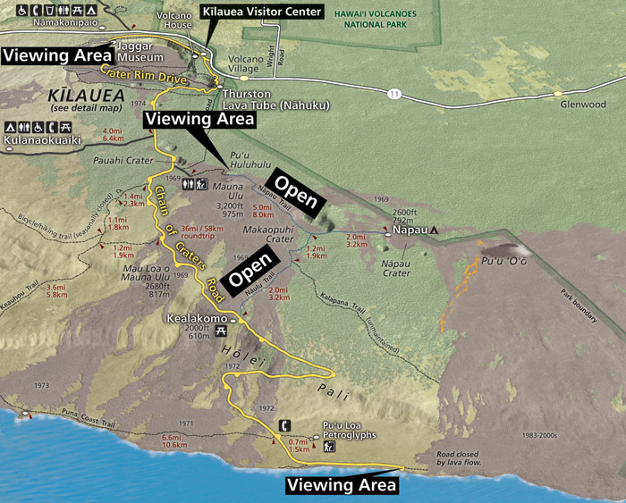
In June, 2012, the Park opened a 0.8-mile/1.3-kilometer stretch of Crater Rim Drive, as well as a similar portion of the Crater Rim Trail, which parallels the road on the other side of Keanakāko‘i Crater, to hikers, so that Park visitors could walk to see that crater and view the summit eruption from a different, lower angle.
This map (pdf) shows you all of the Park, except the lower portion of the Kahuku Unit, where it meets the highway, in southern part of the Ka‘ü District.
Guides
A Hawai‘i Island man who offers guided hikes is Warren Costa. You can contact him at 1-808-982-7575 or via his web site; he will take you out during the day and is very personable, knowledgable, and professional.
There are numerous guides, who will take you out to surface flows, when they are accessible. Here are a few:
- Greg Nottingham, a “broker”, who arranges for local guides to take people out to the lava flows, where and whenever there are accessible lava flows.
- David Ewing lives in the East Rift Zone and is a good guide. His phone number is 1-808-315-2256.
- Volcano Discovery/Volcano Geology & Adventure Ecotours - Philip Ong Tel. 1-808-640-4165
- Arthur Wierzchos 1-808-960 1037
- Akamai Adventure Tours & Travel, Hayley and Tyler Ford, who live in Volcano.
- Kalapana Cultural Tours. Their phone number is 1-808-936-0456
East Rift Zone Eruption Map
This map, just below, shows the lava flows which were entering the ocean inside HVNP, in December of 2011; then, the flows backed up to the vent and, until mid-February 2012, were, once again, not visible. Then, the flows once again moved down the pali, in roughly the same area, and reached the ocean in October 2012, as noted above. Just east of the red flow, in the map below, you can see the orange 2007-2011 flows, and what’s left of the eastern portion of what remains of Royal Gardens Subdivision; the last house, “Jack’s House”, got burned, then buried, on March 2nd, 2012. The County Viewing area is at the end of Hwy. 130, just above Kalapana, which is named on the map, just above the ocean in the pale yellow 1986-1992 flow area. Do check the HVO web site for updates, as the status of lava flowing or glowing changes almost daily.
Links
Definitely check the update (below) to make sure which way to go for after-dark viewing of the lava flow or glow.
For the latest updates about continuing changes at Kīlauea volcano, go to:
- http://hvo.wr.usgs.gov/
- http://volcanoes.usgs.gov/hvo/activity/kilaueastatus.php - CHECK THIS FOR DAILY UPDATES REGARDING THE LAVA FLOWS.
- http://volcanoes.usgs.gov/hvo/cams/PCcam/ - Pu‘u ‘Ō‘ō has been refilling with lava; the perched lava lake, on its floor, inside this cone, grew up to reach the top of the surrounding walls, in just five months, between March and August, last year.
- http://volcanoes.usgs.gov/hvo/cams/HMcam/ - This special camera look right down the vent to Kīlauea’s summit eruption lava pond, well below the floor of Halema‘uma‘u pit crater, which, itself, is set in the floor of the caldera. Often, it’s veiled by its own plume of water vapor, ash, and gasses. At night, Hawai‘i time, of course, you can sometimes see the cracked surface of the active pond, in black-and-white. The pond level dropped quite far down, when the fissures opened up in the ERZ in early March, 2011, but it’s visible again and rather close to the floor of the pit crater, having moved back up, inside the vent.
- http://volcanoes.usgs.gov/hvo/cams/KIcam/ - This one affords a fine view of the west side of Kīlauea Caldera and the pit crater, Halema‘uma‘u, and its current activity. Once you’re standing at the viewing area of Jaggar Museum, you, too, can be on candid camera and can call your friends to let them know how to view you, as well as Kīlauea caldera! ;>)
- http://volcanoes.usgs.gov/hvo/cams/ shows all the Web cams with thumbnail photos. You can access them all from this page.
- http://hvo.wr.usgs.gov/kilauea/update/maps.html
- http://hvo.wr.usgs.gov/kilauea/update/archive/2008/Oct/Oct122008_0728event_x3speed.mov - This movie was taken of the explosive eruption which took place briefly on October 12, 2008, at the site of the continuing eruption at Halema‘uma‘u pit crater, on the floor of Kīlauea caldera. This vent hasn’t had an explosive episode since the first year of its ongoing eruptive activity; occasionally, sections of the vent wall crack from the heat of the pond and collapse, sending up ash, and the material that falls down into the lava pond then melts. The opening on the floor of Halema‘uma‘u keeps widening, in this way.
- http://www.nps.gov/havo/photosmultimedia/multimedia.htm - The Park embarked on a new way to keep visitors up-to-date with the ongoing eruption of Kīlauea volcano, utilizing the Park website. This link directs you to an update video as well as other videos of interest. They’ll be updating this page frequently.
- http://hvo.wr.usgs.gov/kilauea/update/archive/2008/Aug/HalemaumauLavaLake_05Sept2008.mov shows a video of the 156-foot/47.5-meter-diameter lava pond, 333 feet/100 meters down the vent pipe below the 215-foot/65.5-meter vent opening of the current Halema‘uma‘u eruption. The opening is much wider, now, due to the occasional collapses of sections of the wall encircling the lava pond.
For updated information about SO2 levels and wind direction, go to: http://www.hawaiiso2network.com/.
Old Map
THIS IS THE PREVIOUS MAP OF THE PARK, SHOWING Kīlauea’S SUMMIT AREA. Volcano Village is in the upper right corner of this map.
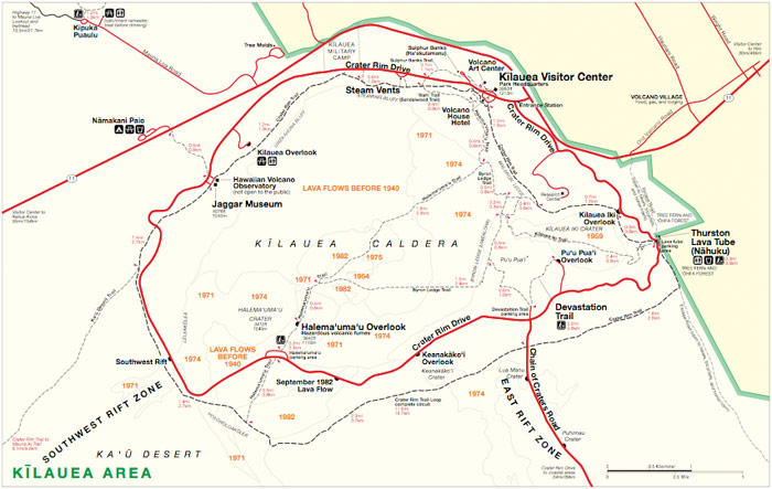
PLEASE NOTE: This older map (above) doesn’t show that the Crater Rim Drive is blockaded (closed) between Jaggar Museum and the west side of the Devastation Trail parking area and Chain of Craters turnoff, due to the continuing eruption in Halema‘uma‘u pit crater, on the floor of Kīlauea Caldera. That eruption is emitting unhealthy levels of gasses. Please refer to the HVO web site for more information.
Here’s a link to another map of the caldera, showing historic eruptions.
The “new” map of the entire Park is available at http://www.nps.gov/havo/planyourvisit/upload/entire_park_final.pdf (pdf).
TOP O’ THE MOUNTAIN LINKS
Maunaloa (That’s the old-fashioned spelling of the name.)
http://hvo.wr.usgs.gov/cams/MLcam/ will show you Moku‘āweoweo caldera, up at the top of Maunaloa.
http://www.mlo.noaa.gov/livecam/livecam.html (the Maunaloa Observatory at 11,135-foot elevation)
Maunakea (Again, the old-fashioned spelling)
http://mkwc.ifa.hawaii.edu/current/cams/index.cgi?mode=multi will show you the summit of Maunakea, “White Mountain” (literally, ‘mountain white’), from different observatories, as well as Maunakea’s summit, viewed from Maunaloa’s weather station (at over 11,00-foot elevation). Snow boarders will check this site to see if it’s worth the drive up there.
Obviously, you’ll want to check out these three sites in the daytime HST.
MAPS
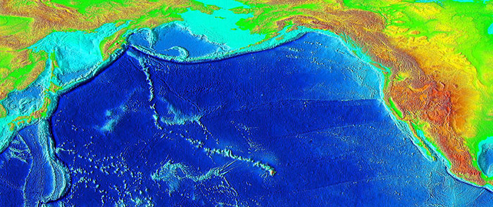
Here’s a map of the Pacific Ocean, showing the Hawaiian Islands, and the ancient Emperor Seamounts, which all formed over the same hotspot which is currently “growing” the “Big” Island, as well as Lō‘ihi. Hawai‘i is the second longest state among the fifty United States, being 1,522 miles/2,450 kilometers from end (Cape Kumukahi on the Hawai‘i Island’s easternmost point) to end (Kure Atoll).
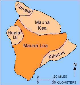
This map shows the five volcanoes of Hawai‘i Island. The only one which is extinct is Kohala, having last erupted about 120,000 years ago. Hualālai, which looms over Kailua-Kona, last erupted in 1801, and Maunakea, 4,500 years ago. Hualālai will certainly erupt again; Mauna Kea is likely to erupt at some point, as well. Go to the HVO web site for more information about Hawaiian shield volcanoes. There is more about Maunaloa and Kīlauea, the two volcanoes in Hawai‘i Volcanoes National Park, below.
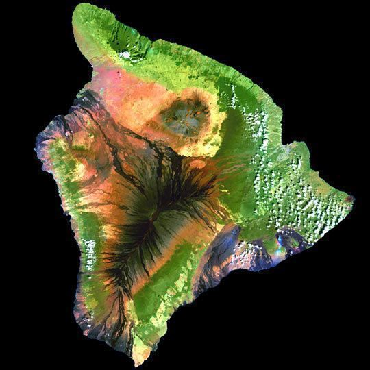
Just below is a Landsat mosaic photo of the island. It shows Maunaloa (that’s the old-style spelling of the name) and Kīlauea lava flows in black streaks. Most Hawaiian shield volcanoes have three rift zones. You can see those of Maunaloa going to the northeast (toward Hilo, in tan colored streaks), the southwest, and the northwest, between Hualālai and Maunakea. According to the USGS site, “Rising gradually to more than 4 km above sea level, Mauna Loa is the largest volcano on our planet. Its long submarine flanks descend to the sea floor an additional 5 km, and the sea floor in turn is depressed by Mauna Loa's great mass another 8 km. This makes the volcano’s summit about 17 km (56,000 ft) above its base! The enormous volcano covers half of the Island of Hawai‘i and by itself amounts to about 85 percent of all the other Hawaiian Islands combined. Mauna Loa is among Earth’s most active volcanoes, having erupted 33 times since its first well-documented historical eruption in 1843. Its most recent eruption was in 1984. Mauna Loa is certain to erupt again, and we carefully monitor the volcano for signs of unrest.” Until now, Maunaloa had not paused between eruptions for more than twenty-five years at a time since its activity was first documented. It last erupted in 1984, from March 25 to April 15. That flow is visible in the photo below, among the tan streaks going down the northeast rift zone from near the summit and moving toward Hilo, that large sharkstooth-shaped bay on the windward (east) coast. http://hvo.wr.usgs.gov/maunaloa/history/1984.html For an amazing panoramic view of Maunaloa’s summit crater, Moku‘aweoweo, go to http://hvo.wr.usgs.gov/cam3 during daylight hours HST.
Apparently, we can thank the over-thirty-year-long eruption of Pu‘u ‘Ō‘ō in Kīlauea’s ERZ for keeping Maunaloa quiet; Frank Trusdell, a geologist at HVO, after much study of all the available data, concluded that activity in Kīlauea’s ERZ can have that quieting effect on Maunaloa. It also may be that Kīlauea’s location, like a bump or bulge on the southeast slope of Maunaloa, might, if Maunaloa erupted and sent lava down that slope, divert such flows, protecting Volcano Village, in the process.
Kīlauea, in the shadow of Maunaloa, has only two rift zones, one to the east and one to the southwest. It has no northwest rift zone as that’s where it butts up against the east flank of Maunaloa.
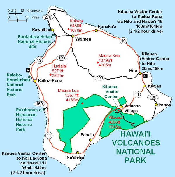
The following map illustrates the national parks on the island. It shows the land which was added to HVNP, on the mauka ("toward the mountain") side of the Kahuku Ranch lands, the portion that follows the southwest rift zone of Mauna Loa from Highway 11 to the volcano’s summit. This large tract of land was an exceptional acquisition for the Park, purchased with the help of the Nature Conservancy; the Kahuku Unit is generally only open on weekends, as there is very limited infrastructure, but there’s a scenic circular trail, called the Palm Trail, which isn’t long or too difficult.
In summary, there are two volcanoes in HVNP, Maunaloa and Kīlauea. The former last erupted in March-April of 1984, for twenty-two days, sending lava toward Hilo, though the flows never reached the town. Maunaloa has never gone this long between eruptions, in historic time. Meanwhile, Kīlauea’s East Rift Zone (ERZ) eruption, out of Pu‘u ‘Ō‘ō vent, has been going continuously since January 1983 and, in March 2008, Kīlauea started a secondary eruption at its own summit.
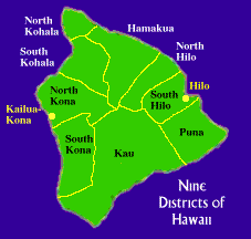
The map, below, shows the political districts of the island. Volcano Village is in “upper” Puna. This web site gives information about the island’s districts.
UPDATED 12/11/13