Volcano Update
October 31, 2014
Kilauea has two eruptions going on simultaneously, one, an underground lava pond on the floor of a pit crater, Halema‘uma‘u, on the floor of Kīlauea Caldera, which began in March 2008, and the other, Pu‘u ‘Ō‘ō, in Kīlauea’s East Rift Zone (ERZ), being fed by underground conduits from Kīlauea’s magma reservoir (below the summit caldera), which began January 3, 1983.
During the ERZ’s almost-thirty-two-year eruption, lava has headed down the hill, burying a town (Kalapana), a Hawai‘i Volcanoes National Park (HVNP) visitors’ center, an ancient Hawaiian temple site, a subdivision named Royal Gardens, and over nine miles/14.4 kilometers of Chain of Craters Road. Since late June, this year, the current flows, named “June 27 flow”, have been moving northeast of Pu‘u ‘Ō‘ō, headed into new territory, approaching Highway 130, Pāhoa town, and lower Puna subdivisions.

The satellite maps are being updated frequently by Hawaiian Volcanoes Observatory (HVO), as the lava approaches developed areas. See the links below.
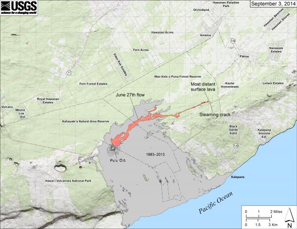
The map below shows the lava’s position in early September; it has moved quite a distance since then, but we include that map, below, to illustrate that Volcano Village, where our cottages are located, is well uphill of Kīlauea’s ERZ. The village is on the middle of the left side of the map, below; it is above Highway 11 (which is not labelled on the map) and is adjacent to the summit area of Hawai‘i Volcanoes National Park (HVNP), where the summit’s eruptive vent is underground and not producing surface flows. All areas of HVNP are accessible, and no portion of the Park is closed off due to the current ERZ flows.
You can access more information about the current ERZ lava flows on HVO’s Web site.
Daily updates: http://hvo.wr.usgs.gov/activity/kilaueastatus.php
ERZ flow maps: http://hvo.wr.usgs.gov/maps
Web cams: http://hvo.wr.usgs.gov/cams/
Big Island Visitors Bureau: http://www.gohawaii.com/big-island/special-alert1